
This is custom heading element
 The main purpose of the Instrument Data Quality Evaluation and Analysis Service â Quality Assurance for Earth Observation (IDEAS-QA4EO) project WP 2250-2251 “DOAS-BO: Towards a new FRM4DOAS site in the Po Valleyâ is the creation of the first Italian Multi AXis – Differential Optical Absorption Spectroscopy (MAX-DOAS) measurement site compliant to the Fiducial Reference Measurement for DOAS (FRM4DOAS) requirements. This goal is achieved by exploiting the SkySpec-2D ground-based MAX-DOAS instrument, developed by Airyx and acquired* by the Italian research institute Consiglio Nazionale delle Ricerche â Istituto di Scienze dellâAtmosfera e del Clima (CNR-ISAC).
The first stage of the project consisted of the assessment of the SkySpec-2Dâs performance. This target has been pursued through two measurement campaigns, one against the TROPOspheric Gas Analyser Spectrometer (TROPOGAS), a custom-built MAX-DOAS instrument owned by the CNR-ISAC, and the other one against the Pandora#117, a reference instrument installed at the Boundary layer Air Quality-analysis Using Network of Instruments (BAQUNIN) super-site in La Sapienza University (Rome). Since October 2021, the SkySpec-2D has been installed at its permanent position at the “Giorgio Feaâ observatory, where it is continuously measuring MAX-DOAS Visible (VIS) and Ultra-Violet (UV) diffuse solar spectra.
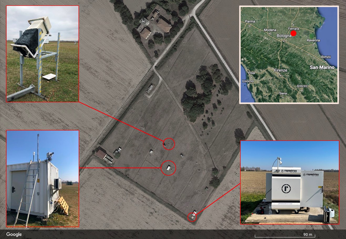
As shown in the figure, the “Giorgio Feaâ observatory (https://www.isac.cnr.it/it/node/7803, Latitude: 44.65° N, Longitude: 11.62° E, Altitude: 11 m a.s.l.) is located at the rural site of San Pietro Capofiume – Bologna, Italy (SPC). The site, founded in the early 1980s, is managed by the Agenzia Regionale per la Prevenzione, lâAmbiente e lâEnergia (ARPAE) of Emilia Romagna, while CNR-ISAC operates in the field under the umbrella of a long-term agreement with ARPAE. The station is equipped for in-situ monitoring of trace gases and particulate matter sampling. ARPAE also runs radar measurements and radio soundings. The station is part of the European Research Infra-structure ACTRIS. Currently, a MAX-DOAS instrument (below left of the figure), an Automatic LIDAR/Ceilometer (top left of the figure) and a CIMEL CE318-T which is part of the AErosol RObotic NETwork (AERONET) are operating on the site. Moreover, a Raymetrics LIDAR (below right of the figure) is in the setting up phase.
The MAX-DOAS spectra are useful to infer information on trace gases concentrations that absorb VIS and UV radiation, such as nitrogen dioxide (NO2), ozone (O3), water vapor (H2O), formaldehyde (HCHO), glyoxal (CHOCHO) and sulphur dioxide (SO2). In particular, zenith spectra provide information on the total Vertical Column Densities (VCDs), while off-axis spectra are particularly suitable to retrieve vertical profiles in the lower part of the troposphere. Since the “Giorgio Feaâ observatory is located far away from important local emission sources and the acquired spectra fully meet the FRM4DOAS standard requirements, these measurements are particularly suitable to validate satellite data. Moreover, they are representative of the background level of pollution in the Po Valley, allowing to perform air quality studies in one of the most polluted regions in Europe.
* Project “Sviluppo delle Infrastrutture e Programma Biennale degli Interventi del Consiglio Nazionale delle Ricerche – Potenziamento Infrastrutturale: progetti di ricerca strategici per lâente. Progetto 32âASSE NORD Pianura Padana Mt. Cimone, Bologna, San Pietro Capofiumeâ
Бонусы Vavada: акции для новых и постоянных игроков
Бонусная система vavada вход направлена на поощрение активности игроков и включает предложения как для новичков, так и для постоянных клиентов. Новые пользователи могут рассчитывать на приветственные бонусы, которые увеличивают стартовый банкролл и позволяют дольше знакомиться с играми. Для активных игроков регулярно проводятся акции, турниры и специальные предложения с дополнительными начислениями. Бонусы имеют прозрачные условия отыгрыша, которые подробно описаны в правилах. Это позволяет заранее оценить требования и выбрать наиболее подходящие акции. Кроме того, Vavada периодически запускает временные предложения, приуроченные к праздникам или крупным событиям. Все бонусы активируются через личный кабинет, а информация о текущих акциях доступна в отдельном разделе сайта.
- Приветственные бонусы для новичков
- Регулярные акции и турниры
- Прозрачные условия отыгрыша
- Удобная активация бонусов
Online casinos offer a wide variety of games, from classic table games to modern video slots. Players can enjoy the excitement of spinning the reels, including the popular temple tumble slot, from the comfort of their homes.
Hľadáte spoľahlivé možnosti pre online hazardné hry? Preskúmajte rozsiahly výber hier a bonusov. Pre slovenských hráčov sú dostupné rôzne možnosti, vrátane zahranicne kasina pre slovakov, ktoré ponúkajú rozsiahle portfólio.
Кэт казино Россия: логика отображения информации на платформе
Cat Casino для пользователей из России выстраивает отображение информации таким образом, чтобы пользователь мог быстро воспринимать данные и не сталкивался с перегруженностью интерфейса. Все блоки информации структурированы и расположены в удобной последовательности.
Каждый раздел содержит только необходимую информацию, что упрощает взаимодействие и делает процесс более понятным. Пользователь не отвлекается на лишние детали и может сосредоточиться на основной задаче.
Дополнительно используются визуальные акценты, которые помогают выделять важные элементы и ускоряют поиск нужной информации. Это делает интерфейс более удобным и функциональным.
Система отображения остаётся стабильной, что позволяет быстро привыкнуть к структуре и не тратить время на адаптацию при каждом входе.
Таким образом cat casino обеспечивает логичное и удобное отображение информации, улучшая общий пользовательский опыт.
- чёткая структура информации
- минимум лишних элементов
- визуальные акценты
- удобное восприятие данных
- стабильная структура
Τα online casino προσφέρουν μια μεγάλη ποικιλία παιχνιδιών, από κουλοχέρηδες μέχρι επιτραπέζια. Ανακαλύψτε τα καλυτερα online casino και απολαύστε μια ασφαλή και διασκεδαστική εμπειρία.
Online casino's bieden een breed scala aan spellen. Spelers kunnen slots, tafelspellen en live casino-opties vinden. Ontdek de spanning en mogelijkheden en speel met buffalo king megaways echt geld.
ice casino cashback bonusΗ αδρεναλίνη ανεβαίνει καθώς περιστρέφετε τους τροχούς στα αγαπημένα σας online slots. Ανακαλύψτε μια τεράστια συλλογή παιχνιδιών, από κλασικά φρουτάκια έως μοντέρνες κυκλοφορίες. Ζήστε την απόλυτη εμπειρία ψυχαγωγίας στο το Spinzen Casino, όπου η διασκέδαση δεν σταματά ποτέ.
Seeking premium digital gaming? Our platform offers diverse slots and engaging live dealer tables. We guarantee secure deposits and fair outcomes. Find big wins at GladiatorsBet's Online Casino for paramount fun.
Η ασφάλεια και η αξιοπιστία είναι πρωταρχικής σημασίας. Επιλέξτε πλατφόρμες με άδειες λειτουργίας για μια ξέγνοιαστη εμπειρία. Εμπιστευτείτε την ποιότητα της wishking για το online παιχνίδι σας.
Vavada казино: безопасность данных и защита аккаунта
Vavada применяет комплексный подход к защите учетных записей пользователей. Внутренние процедуры направлены на предотвращение несанкционированного доступа и соблюдение правил использования платформы.
Регистрация сопровождается подтверждением основных данных, что помогает снизить риски неправомерных действий. Дополнительные проверки могут применяться при выполнении отдельных операций.
Информация о принципах обработки данных представлена в отдельном разделе сайта. Пользователь может ознакомиться с основными положениями и понять порядок хранения сведений.
Личный кабинет предоставляет инструменты для контроля активности и изменения параметров безопасности. Это позволяет своевременно реагировать на возможные изменения.
Система защиты в вавада зеркало ориентирована на стабильность и прозрачность процессов. Четкие регламенты помогают поддерживать порядок и доверие к сервису.
- Подтверждение регистрационных данных
- Дополнительные проверки при необходимости
- Информация о принципах обработки данных
- Инструменты контроля активности
Giocare nei casinò online è diventato molto popolare. La varietà di giochi offerti è ampia e accessibile. Scopri i migliori siti di casino online europei per un'esperienza di gioco sicura e divertente.
https://migliori-casinoonline.it/Online casino's bieden een breed scala aan spellen, van slots tot tafelspellen, die spelers online kunnen spelen. De populariteit groeit snel, en er zijn veel opties beschikbaar, zoals Voetbal Wedden Zonder Cruks, om uit te kiezen.
Giocare nei casinò online offre diverse opzioni di gioco, dai classici tavoli ai giochi più moderni. Per chi cerca nuove esperienze, casino online stranieri rappresentano una valida alternativa.
Ανακαλύψτε μια μεγάλη ποικιλία παιχνιδιών και επιλογών ψυχαγωγίας. Η casino online προσφέρει μια ασφαλή και αξιόπιστη πλατφόρμα για τους παίκτες. Απολαύστε συναρπαστικά παιχνίδια καζίνο από την άνεση του σπιτιού σας.
Online Casinos bieten eine Vielzahl von Spielen, von Spielautomaten bis hin zu Tischspielen. Spieler können bei betalright verschiedene Online-Casinos finden und vergleichen, um das passende Angebot zu entdecken.
Giocare d'azzardo online offre varie opzioni, tra cui slot e giochi da tavolo. La sicurezza è fondamentale, quindi è importante scegliere piattaforme affidabili. Per giocare in modo sicuro, considera casinò online senza documenti e verifica le licenze.
Les casinos en ligne offrent une grande variété de jeux, des machines à sous au poker. Pour une expérience de jeu en ligne fiable, découvrez olympe casino france, une option populaire pour les joueurs.
Online Casinos bieten eine Vielzahl von Spielen, von Spielautomaten bis hin zu Tischspielen. Spieler können bequem von zu Hause aus spielen. Besuchen Sie https://interweten17.ch/ für weitere Informationen und Optionen.
Online casinos offer a wide variety of games, from slots to table games, for players to enjoy. Many people are now trying their luck at australia online casino sites for entertainment and potential winnings.
Online casinon erbjuder ett brett utbud av spel, från klassiska bordsspel till moderna spelautomater. För en säker spelupplevelse, överväg att utforska slottio online casino och dess erbjudanden.
Online-Casinos bieten eine vielfältige Auswahl an Spielen. Spieler können von überall auf der Welt teilnehmen. Besuchen Sie zodiac, um mehr über die verfügbaren Optionen zu erfahren und Ihr Glück zu versuchen.
Giocare online offre una vasta gamma di opzioni, dai classici giochi da tavolo alle slot machine. Per un'esperienza sicura, è importante scegliere un sito affidabile come casino senza AAMS e verificare le licenze.
Online casinos offer a wide variety of games for players to enjoy from the comfort of their homes. For those in Australia, best online casinos australia provide a safe and regulated environment for online gambling.
A szerencsejáték izgalmas lehet, de fontos a felelősségteljes játék. A legjobb online kaszinok kínálatában számos játékot találhatsz, melyek különböző élményeket nyújtanak. Mindig tájékozódj a szabályokról.
Spielen in einem online casino ausland kann eine bequeme Option sein, um verschiedene Casinospiele von zu Hause aus zu genießen. Es ist wichtig, die Lizenzierung und Regulierung zu überprüfen.
Chupakabra styleGiocare online offre una vasta gamma di opzioni, dai classici giochi da tavolo alle slot machine più moderne. Per chi cerca nuove esperienze, casino non aams propone piattaforme alternative.
Η διασκέδαση και η ψυχαγωγία είναι στο επίκεντρο των παιχνιδιών καζίνο. Η επιλογή παιχνιδιών είναι μεγάλη, και μπορείτε να παίξετε σε ένα online casino από την άνεση του σπιτιού σας.
Fedezze fel a legjobb online kaszinok kínálatát, ahol izgalmas játékok és bónuszok várják. A biztonságos és megbízható platformok garantálják a gondtalan szórakozást minden játékos számára.
Los casinos en línea ofrecen una experiencia de juego accesible y variada. Los jugadores pueden disfrutar de una amplia gama de juegos desde la comodidad de su hogar, visitando https://casinossinlicencia.co.com/ para más información.
Online casinos offer a diverse range of games, from slots to table games, providing entertainment for players worldwide. For an exciting experience, try spinbet and explore various gaming options.
Les joueurs peuvent explorer une variété de jeux sur un casino en ligne étranger, offrant des expériences uniques et des opportunités de gains intéressants, tout en profitant de la commodité du jeu à distance.
Online casinos provide a convenient way to enjoy various games from home. Players can explore options like slots and table games at lucky ones casino Australia, enhancing their gaming experience.
Τα διαδικτυακά καζίνο προσφέρουν μια ποικιλία παιχνιδιών και ευκαιριών για τους παίκτες. Μπορείτε να απολαύσετε την εμπειρία του casino online από την άνεση του σπιτιού σας.
Online-Casinos bieten eine Vielzahl von Spielen und Möglichkeiten, um zu gewinnen. Spieler können sich für ein ausland casino entscheiden, um von attraktiven Boni und internationalen Spieloptionen zu profitieren.
Online-Casinos bieten eine Vielzahl von Spielen und Unterhaltungsmöglichkeiten. Spieler können bequem von zu Hause aus spielen, während sie auf Plattformen wie ausland casino ihre Lieblingsspiele genießen.
nvcasinoAz online kaszinók népszerűsége folyamatosan növekszik, de fontos, hogy a játékosok figyeljenek a biztonságra is. Az új kaszinók biztonság új kaszinók biztonság kiemelt figyelmet érdemel, hiszen a megbízható platformok garantálják a játékosok védelmét és a fair játékot.
Negli ultimi anni, i casinò online hanno guadagnato popolarità in Italia, offrendo una vasta gamma di giochi e opzioni di intrattenimento. Tuttavia, è importante fare attenzione e scegliere solo piattaforme affidabili, come i casino italiani non AAMS, per garantire un'esperienza di gioco sicura e legale.
nv casinoI casinò online offrono un'ampia varietà di giochi e opportunità di intrattenimento, ma è importante scegliere piattaforme affidabili. Un'opzione da considerare è il casino non aams che fornisce informazioni su casinò non aams, garantendo una scelta consapevole per gli utenti.
I casinò online offrono un'ampia varietà di giochi e opzioni di intrattenimento, rendendo il gioco accessibile a molti. È possibile trovare piattaforme che permettono di giocare senza la necessità di inviare documenti, come nel caso dei casino online senza documenti, che semplificano ulteriormente l'esperienza per gli utenti.
Discover the thrill of spinning slots and hitting jackpots at the fastest payout online casino Canada offers for unbeatable gaming excitement.
Discover thrilling jackpots and unbeatable odds with the top bookmaker non aams for your ultimate casino adventure.
Experience thrilling wins and massive jackpots at the Online Casino Zonder Cruks, where excitement never ends!
Experience thrilling wins and massive jackpots today at the vavada казино, your ultimate destination for online slots and casino fun.
Experience thrilling wins and massive jackpots at the вавада казино официальный сайт, your top choice for online slots and gaming excitement.
Experience thrilling wins and massive jackpots at your favorite online magyar casino and enjoy nonstop slot action today!
Discover the thrill of winning big at the legjobb magyar online casino with exciting slots and massive jackpots today!
Experience the thrill of spinning reels and massive jackpots with tower rush – your ultimate online casino adventure!
Experience thrilling wins and massive jackpots at the best payid australian casino for nonstop online gaming excitement.
Discover the best jackpots and thrilling slots today by visiting goksites for top-notch online casino fun.
Discover thrilling jackpots and nonstop action at 888starz uz, your ultimate destination for online casino excitement.
Experience the thrill of jackpots and nonstop fun at 888 starz, your ultimate destination for online casino excitement.
Vavada казино: удобство использования на разных устройствах
Vavada адаптирована для работы на компьютерах, планшетах и смартфонах, сохраняя единый функционал. Независимо от устройства пользователь получает доступ к основным разделам и игровому каталогу.
Интерфейс автоматически подстраивается под размер экрана, обеспечивая удобное расположение элементов. Кнопки и меню остаются читаемыми и функциональными.
Навигация остается логичной и последовательной даже при смене устройства. Пользователь может продолжить использование платформы без потери данных и настроек.
Оптимизация под различные форматы экранов позволяет сохранять стабильную скорость загрузки и корректное отображение контента.
Универсальность вавада делает платформу гибкой и доступной. Возможность выбора устройства повышает комфорт и расширяет варианты использования сервиса.
- Поддержка разных типов устройств
- Адаптивный интерфейс
- Сохранение функционала на всех экранах
- Стабильная работа вне зависимости от формата